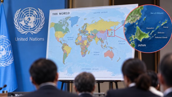
The adoption of a new world map based on the Equal Earth projection has ignited a debate over territorial representation, particularly concerning the depiction of the Kuril Islands. This projection aims to more accurately reflect the relative sizes of continents compared to the traditional Mercator projection. Consequently, the new map shows Africa as much larger, while Europe and North America appear reduced in size relative to their portrayal on many conventional maps.
Japan has raised concerns about the representation of the Kuril Islands, which it calls the Northern Territories. On the new map, these islands are depicted in the same color as Russia, a portrayal Japan argues could cause confusion regarding its stance on the disputed territory. The Kuril Islands, a chain located between Japan’s northern region and Russia’s Kamchatka Peninsula, have been a point of contention for decades, emphasizing their importance as both a geographical and historical issue in the area.
This controversy underscores the power of map design in shaping perceptions of borders, territories, and ownership. Different mapping systems can alter the visual presentation of countries and continents, even though their actual size or location remains unchanged. The Equal Earth projection was created to offer a more balanced view of global land areas, unlike the Mercator projection, which often exaggerates the size of regions near the poles. Equal Earth preserves the proportional size of continents while fitting the entire world onto a single map.
The ongoing discussion about the new map highlights that maps serve purposes beyond mere navigation. Their use of color, border delineations, and geographical labels can have substantial cultural and political implications, especially in regions with contested territorial boundaries. For travelers and geography enthusiasts, the Equal Earth projection provides a novel perspective on the world, illustrating how significantly the appearance of familiar places can shift depending on the mapping system used.